Bridge profile
Perry Bridge, Birmingham
Perry Barr, Birmingham, England
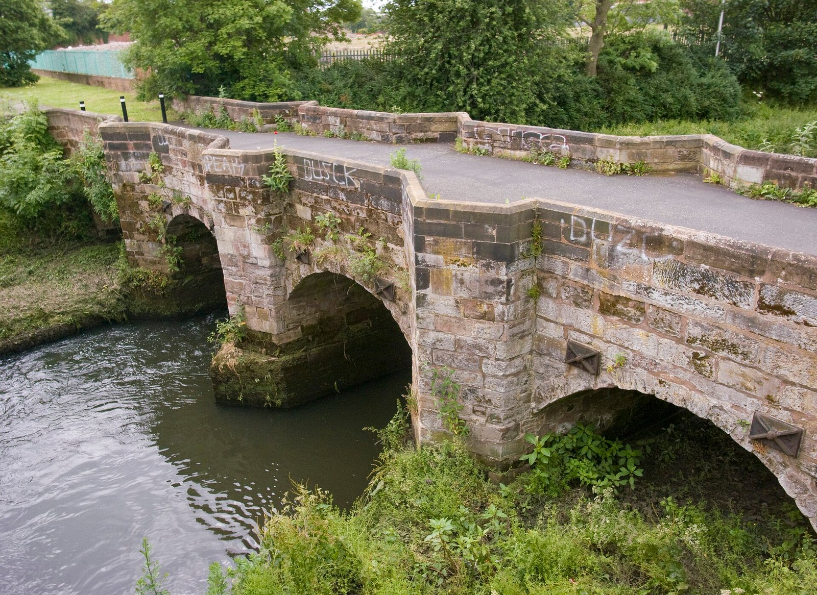
Built in its present form in 1711, Perry Bridge carries pedestrians over the River Tame beside a much younger road bridge, preserving an older crossing in modern Birmingham.
At a glance
Key facts
Location
First opened
1711, incorporating an earlier medieval bridge
Crosses
River TameRivers
Bridge type
Visit and use
History
Alternative names
Zig Zag Bridge, Old Perry Bridge, Packhorse Bridge
Ownership and maintenance
Owner
Birmingham City Council
Maintained by
Birmingham City Council
Design and dimensions
Main materials
Total length
Approximately 50 meters / 164 feet including the approach causeway
Number of spans
4
Perry Bridge is easy to overlook. It stands beside a much wider road bridge on Aldridge Road, surrounded by the movement and noise of modern Birmingham. Look more closely, however, and the smaller crossing reveals a far older route across the River Tame.
The red sandstone bridge dates to 1711 in its present form, although Historic England describes it as an eighteenth century refurbishment of a medieval bridge. Once used by horses, carts and local travelers, it is now reserved for pedestrians.
The short version
An old bridge beside its replacement
Perry Bridge is a four span sandstone bridge over the River Tame in Perry Barr. It carried road traffic until a wider bridge opened beside it in 1932. The historic crossing now provides a pedestrian route and survives under two forms of national heritage protection.
When was Perry Bridge built?
The date requires a little explanation. Birmingham’s Sites and Monuments Record says Staffordshire Quarter Sessions probably ordered a stone replacement for an earlier wooden horse bridge in 1709. A surviving record of the neighboring modern bridge dates Perry Bridge in its present form to 1711.
Historic England takes the story further back. Its official listing for Perry Bridge describes the structure as an eighteenth century refurbishment of a medieval bridge.
The safest conclusion is that travelers were crossing the River Tame here before 1711, while the recognizable sandstone bridge took its present form during the early eighteenth century.
What crossed the River Tame before the stone bridge?
The local heritage record refers to an earlier wooden horse bridge. These simple crossings were essential parts of local travel, allowing people, horses and goods to move across rivers that could otherwise interrupt a journey.
Perry Bridge is also sometimes described as a packhorse bridge. Its narrow roadway makes sense for horses and light traffic, but the bridge later formed part of a busy route toward Sutton Coldfield and Lichfield.
There is a tempting Roman connection too. Older accounts sometimes claim that the Roman road known as Ryknield Street crossed the river on the exact site of Perry Bridge. More recent archaeological work published by Birmingham City Council places the Roman crossing east of the present bridge instead.
Worth knowing
The Roman claim needs caution
A Roman road passed through this part of Perry Barr, but current archaeological evidence suggests its river crossing stood east of Perry Bridge. The old stone bridge remains historic enough without borrowing another thousand years.
How was Perry Bridge designed?
The bridge is built from red sandstone and has four segmental arches. Two arches cross the River Tame, while the outer arches pass over paths beside the river.
Three pointed cutwaters project from the supports. Their shape helps divide the current and reduces the force of water against the stonework. The cutwaters rise to parapet level, creating small pedestrian refuges along the narrow crossing.
The bridge is approximately four meters wide. Its narrow roadway and low stone parapets give it a completely different character from the twentieth century road bridge standing immediately alongside it.
Four important dates
Perry Bridge timeline
Medieval period
An earlier bridge provides a crossing over the River Tame.
1709
A replacement for the wooden horse bridge is probably ordered.
1711
The sandstone bridge takes the form recognized today.
1932
The adjoining road bridge opens and Perry Bridge becomes pedestrian only.
Why is there another bridge directly beside it?
By the twentieth century, Perry Bridge was far too narrow for growing levels of motor traffic. Birmingham constructed a wider replacement immediately to its east during 1931 and 1932.
The newer bridge took over the Aldridge Road traffic, allowing the historic crossing to remain in place. An archive photograph dated October 5, 1932, shows the two bridges together and records that the old bridge had been reserved for pedestrians.
The arrangement makes the site particularly interesting. Visitors can compare an early stone crossing with the road bridge built to replace it without moving more than a few steps.
Why is Perry Bridge protected twice?
Perry Bridge has been a Grade II listed structure since April 25, 1952. It is also a Scheduled Monument, a separate designation used for archaeological sites and structures considered nationally important.
The Scheduled Monument record for Perry Bridge recognizes the crossing under the Ancient Monuments and Archaeological Areas Act. Birmingham City Council includes it among the city’s small collection of nationally protected ancient monuments.
Did you know?
One bridge, two protections
Perry Bridge is both a Grade II listed building and a Scheduled Monument. The first designation recognizes its architectural and historic interest, while the second reflects its national archaeological importance.
Can you walk across Perry Bridge?
Yes. The old bridge is open to pedestrians and no ticket is required. Motor vehicles use the neighboring Aldridge Road bridge.
The bridge stands in Perry Barr beside the River Tame. B42 2EY is a useful postcode for the surrounding section of Aldridge Road, while the exact coordinates are 52.52535, -1.89709.
This is an active urban location rather than a managed visitor attraction. Take care near the road and check current access conditions before making a special journey.
Research
Perry Bridge sources and further reading
Explore the official heritage records, local archives and archaeological sources used to research this bridge profile.
-
Official Grade II listing for Perry Bridge
Historic England -
Perry Bridge Scheduled Monument record
Historic England -
Perry Bridge Sites and Monuments Record
Birmingham Images and Birmingham City Council -
The old and new Perry bridges together in 1932
Birmingham Images -
Birmingham’s Scheduled Ancient Monuments
Birmingham City Council -
Parliamentary record concerning repairs to Old Perry Bridge
UK Parliament
Information checked November 17, 2026.